 Nederlands
 Dansk
Dansk Österreichisch
 Po Polsku
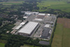


Village Dörverden
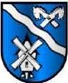
Coat of arms: 'On blue ground a silver wavy bar, in the upper field on the right a gable with horses turning the head outward. Below left a smock windmill'.
The coat-of-arms of the newly founded community Dörverden in 1972 arose from the authorised coat-of-arms of the communities Stedorf and Dörverden from the year 1948.
The silver bar of the river is of crucial importance. It depicts the Weser on the one side and at the same time the Aller on the other as community, district and county border. This demonstrates that both communities are imbedded between the two rivers. The horse's heads also stand for Lower Saxon traditions and language of our immediate homeland. The windmill symbol received importance through the renovation of the mill in Westen and the construction of wind power facilities.
Coat-of-arms design: Heinz Bannier, Dörverden
Residential community interspersed with commercial usage, central village of the community Dörverden founded in 1972, few traditional agricultural used buildings.
Ground level between 14,5m above sea level (in the marsh) and 30m above sea level (on prehistorically drifting sand in Dörverdener Wald)
Traffic development via main road 215, district road 15 (direction village Westen) and district road 17 (direction village Diensthop).
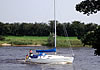
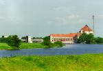
Dörverden is situated directly at the banks of the river Weser (eastern community border).
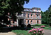
In the village centre several business enterprises, the town hall, a school centre, the church, pubs, hotel-restaurant 'Pfeffermühle'.
Retirement home of the rural district Verden 'Am Hesterberg' and a private old people's home.
Interesting:
- church (St. Cosmae et Damiani)
- access to the Weser bank at the 'Fährweg' a from the 'Sympherallee'
- chestnut avenue in the road 'Sympherallee' with view onto Weser and marsh
- small chic indoor swimming bath at the school centre(opening times: afternoons and evenings)
- hydropower station of E-ON and lock (both built 1910) at the Weser
- Weser cycle trail runs through the community and the weir over the Weser
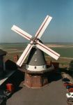
- 1997 restored smock windmill (family Dahnken)
History:
The name 'Dörverden' points probably to ford place through the Weser.
In the 2nd century AC the Alexandrian geographer Ptolemy mentions in his earth description the village 'Tulifurdon'. In all likelihood Dörverden is meant.
A lot points to the fact that Dörverden was located at one of the old north-south trading route.
Excavations from the year 1956 in the area of junction Barmer Weg into the B 215 ('Auf dem Hambusch') resulted cremation burials since the early Iron Age (around 500 BC), later body burials (oldest in 600. century AD), horse graves. The graveyard existed probably well into the 10. century. Finds produced there among others an iron sword and an iron shield boss from the 6./7. century as well as Saxon glass pearls.
In the bulk goods after digging the Weser channel around 1910, a Celtic bronze tool (1. century BC) was found. It points to anitque shipping on the Weser.
In late Middle Age Dörverden was an bailiwick, which later belonged to the Amt Westen.
In 1847 a train stopped for the first time in Dörverden at the then newly constructed railway line Hanover - Bremen.
In 1910 construction started on a barrage in the Weser with hydropower station, channel building in the Weser curve and a weir.
1937 Bau des Steinlagers für Arbeitskräfte der Rüstungsfabrik EIBIA im Barmer Wald. Danach Unterbringung von Zwangsarbeiterinnen und Zwangsarbeitern aus Belgien, Holland, Frankreich, Polen und Russland, sowie Kriegsgefangenen und deutschen Arbeitern.
Nach dem Krieg wurden Heimatvertriebene und Flüchtlinge im Steinlager untergebracht.
1962 schlossen sich Dörverden und Stedorf freiwillig zusammen. Danach wurden zahlreiche Wohngebiete ausgewiesen und mit Einfamilienhäusern bebaut.
In den Folgejahren Ausbau des Schulzentrums (zeitweise mit 800 Schülern).
1970 Schließung des Bahnhofes.
1972 fand in Folge einer landesweiten Gebietsreform durch ein Landesgesetz die Bildung der neuen Einheitsgemeinde Dörverden statt (mit den 10 Ortschaften Ahnebergen, Barnstedt, Barme, Diensthop, Dörverden, Hülsen, Stedebergen, Stedorf, Wahnebergen, Westen).
1976 Bau des Rathauses in Dörverden.
1996 Fertigstellung eines großzügigen Kindergartens in der ehemaligen KdF (Kraft-durch-Freude- Halle) des Steinlagers.
1994/1997 Neugestaltung der Bahnhofstraße und der Großen Straße (B 215).
28.Mai 2000 Wiedereröffnung des Bahnhofes Dörverden.
Dezember 2003 erstmals Nikolausmarkt um die Kirche Dörverden herum.


")


 - Kirchlinteln - Kreepen")


 and all-day school")


